
Main page: Thai locations where I didn't find Nepenthes
Thailand 2004
(January 8 - March 6)
(January 8 - March 6)
| Mt Phanom Thong Mt Hin Rong Kla Chat Trakan Falls Na Haeo Mt Ruea and Mt Luang |
Kaeng Chet Kwae Sak Yai and Khlong Tron Ramkhamhaeng Lam Nam Nan |
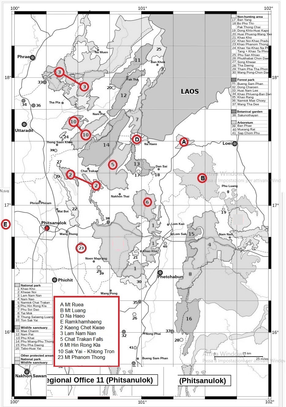
There's no Google Earth, I don't have a GPS. I look for clues at local herbaria. I set a long-term base in Phitsanulok, at the Versailles Mansion, which used to be at 16 49.593, 100 15.453. I want to check the national parks around the city, one by one. I only have one month to do this, and we're talking about seriously extensive areas, mostly unexplored, without trails. I need a quick and practical way to circumvent the issue. So, I face the long and difficult journey to the location (buses, songthaew, lifts, with people who don't speak English, going to places the locals usually don't go to), the location being a national park, a forest park, or a wildlife sanctuary, I look for visitor centres, headquarters, and offices in general, I ask the very kind and patient rangers, officers, or any other person who might be in the know about the local flora, I ask to see all the photos taken in the park and usually kept in a drawer, and then I (try to) go back home. One location per day (with occasional days for rest), with a limited budget, and possibly back in my bed before the night falls. For this page, I found a very nice map that I modified to make all the parks easier to spot, so you can understand at all times where the hell I was.
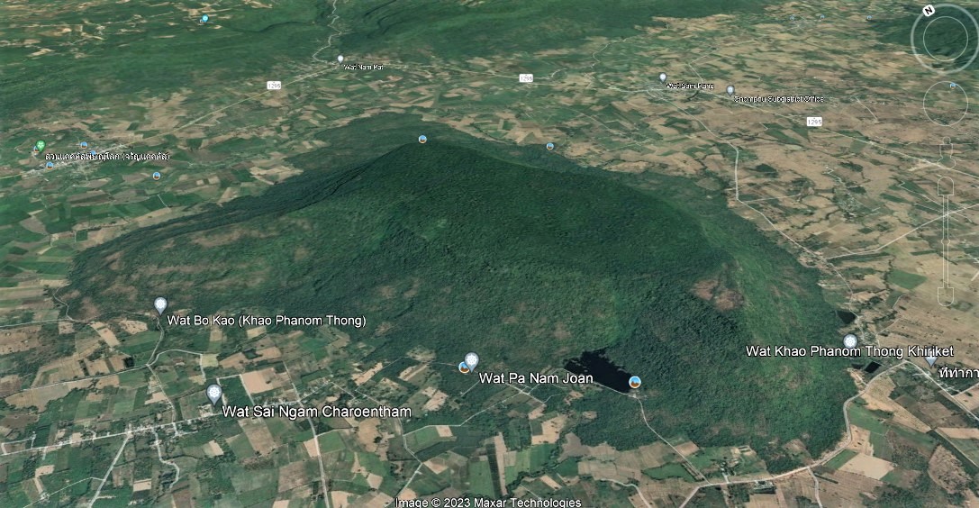
Mt Phanom Thong (January 21). The closest national park is Mt Phanom Thong. On my first attempt, there's no way to reach it. I arrive at Wat Bot and I ask. Nobody has ever heard the name Mt Phanom Thong before. Three weeks later I try again, and I do reach the Mt Phanom Thong area. However, I am told by the local police that the park doesn't exist, it's just a dry mountain.
2023: First of all, it's not clear to me why I went to Wat Bot, which is 25 km north of Phitsanulok, to reach Mt Phanom Thong, which is 30 km south-east (16 39.159, 100 34.278). That should have been clear even on my far-too-large map. The mountain is surrounded by Wat (it means temple, but it can become the prefix of a town), so it is possible that someone told me to reach Wat Bo (at the base of the mountain) to know about Mt Phanom Thong, and when I asked someone else about Wat Bo, they understood Wat Bot, and I went north without even realizing it. Or maybe I wrote Wat Bot on my notes but it was Wat Bo, who knows. About the "existence" of the park: the government's policy was to preserve a certain percentage of Thailand before seeing the whole country covered with plantations. The best way to deal with that was to declare lots of mountain areas as protected, because they host more biodiversity and because they can hardly be used for urban and agricultural purposes. As a result, the process was more like taking a map, encircling an area and saying: "This is now protected", rather than turning it into a tourist attraction based on wildlife enjoyment. Many parks became popular, and small parts of them were functionally developed into tourist attractions. But lots of them are untouched, there's not even an office of reference. That explains the surprised reaction of both me and the police. Mt Phanom Thong is a small plateau, but the top is covered with thick forest, so probably no Nepenthes.
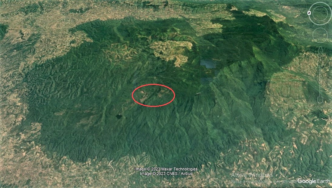
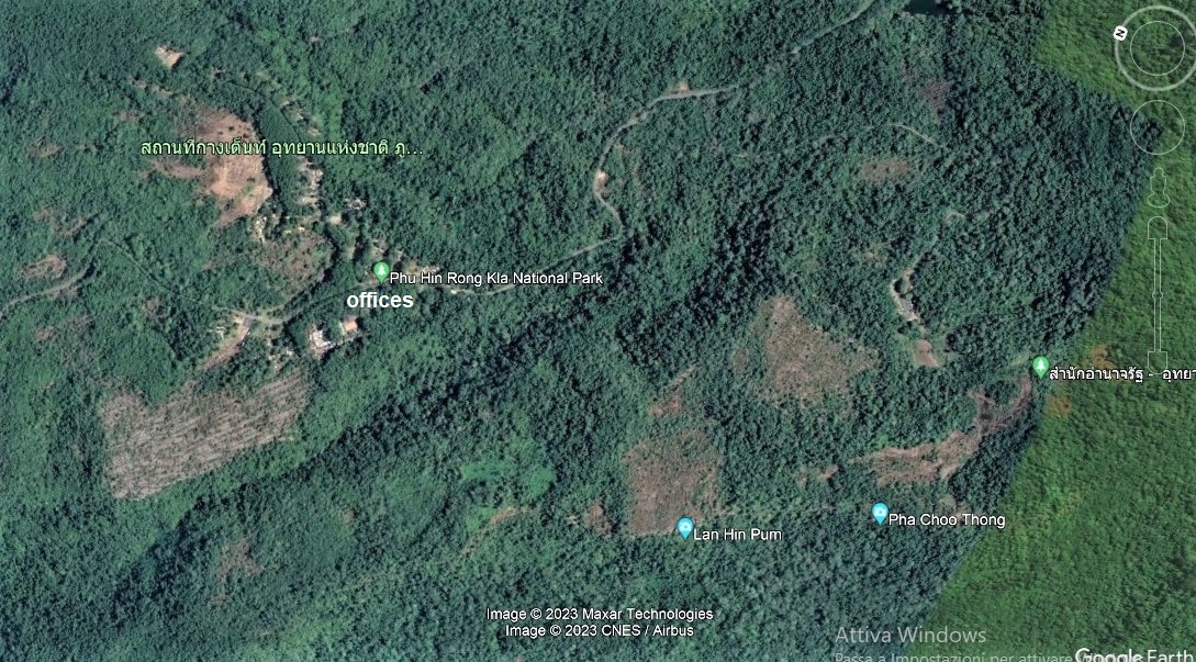
Mt Hin Rong Kla (January 23). A young guy at the visitor centre tells me that the pitcher plants can be found in an area of the park between Lan Hin Pum and Pha Chu Thong. There are no photos of Nepenthes in the office, even if there are plenty of photos of other animals and plants. I run to the area indicated, which is locally very popular. There's a lot of sphagnum, growing on the sides of the big rocks that are peculiar to this place. I also find a lot of sand and something similar to peat. Everything is perfect, including the altitude (c. 1300 m). But I find nothing. Not even a small Utricularia. I ask all tourists along the way if they have seen the pitcher plants. Most of them reply: "Oh, yes, it's, uhm, here around, but I don't remember where". At least seven people give this answer. After a few hours, having explored the whole place, I leave. A few weeks later, I ask my hotel owner to call the park and ask if they have Nepenthes. They say: "No". I'm still not convinced.
2023: The mountain system (16 59.635, 100 59.680) is pretty big, but all the events above happened in the red circle, which is magnified here. Mt Hin Rong Kla is famous for the strange rock formations, and that's where they sent me, but however evocative and surrounded by sand, peat, sphagnum and orchids these are, no Nepenthes have ever been recorded from the park. Still, everybody keeps visiting the same spots, while the satellite shows some small, hidden savannahs that leave some hope.
Chat Trakan Falls (January 25). Plain and simple: "No Nepenthes, sorry, go to Na Haeo, they have".
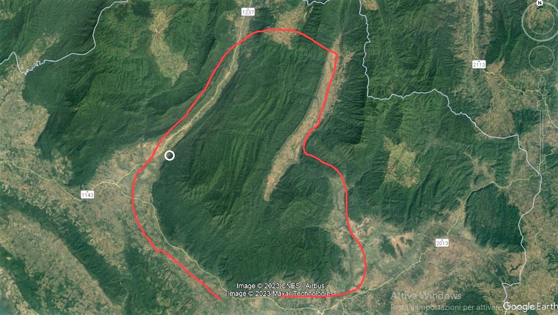
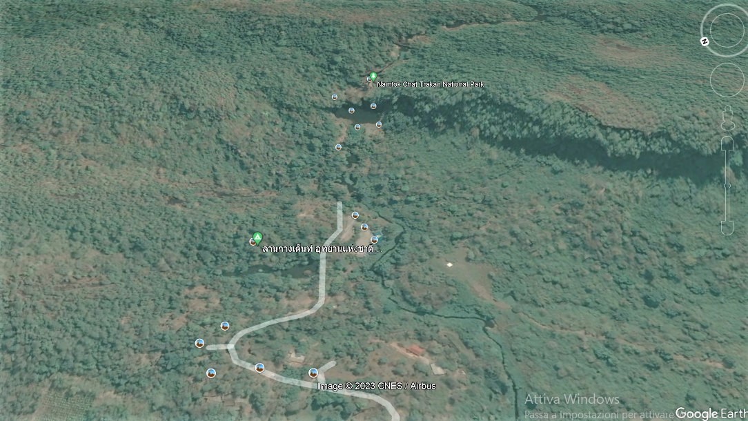
2023: The park is huge (17 16.413, 100 44.427), but just the very small white spot is reachable and used as an attraction: photo. That spot is the waterfall: photo. Not only the staff can't have any idea of what grows in the rest of the park, but the mountain doesn't host the type of forest I'm looking for.
Na Haeo (January 25). At Chat Trakan Falls, I'm told I can find the pitcher plants at Na Haeo. I don't waste any time. I jump on the back of the first pickup that I can stop and I head to Na Haeo. Two hours later, after two lifts and one hour on a songthaew, I ask the driver if we are still far. He says: "No no". Thirty minutes later, I realize that he's not going to Na Haeo, I don't know why. I leave the songthaew and I start walking. Two hours later, I'm now even more lost, in the mountains, looking for the bloody Na Haeo. I'm still walking when I hear the songthaew coming back. The driver decided to try again. He asks for more money, I show my 10 baht. Nonetheless, he accepts and he brings me to the farthest place he can reach. When we stop, a few metres in front of us, a few soldiers are looking at me, with their rifles hanging down and a bored expression on their face. After showing my passport, explaining my present situation, that I'm looking for the pitcher plants, and after confirming - upon request - that I like Vieri and Baggio, they explain that I am in Rom Klao Vlg, at the border with Laos, and that they are the Thai Border Police. When I explain how I came from - and I'm at this point trying to go back to - Phitsanulok, they laugh. Not a good sign. I spend a few hours among those unsettling rifles and those very kind people. One of them insists to give me his email address. Eventually, they stop a car that's going the right way. You won't believe it, but lift after lift, cold mountain after cold mountain, by midnight I was back at the Phitsanulok bus station.
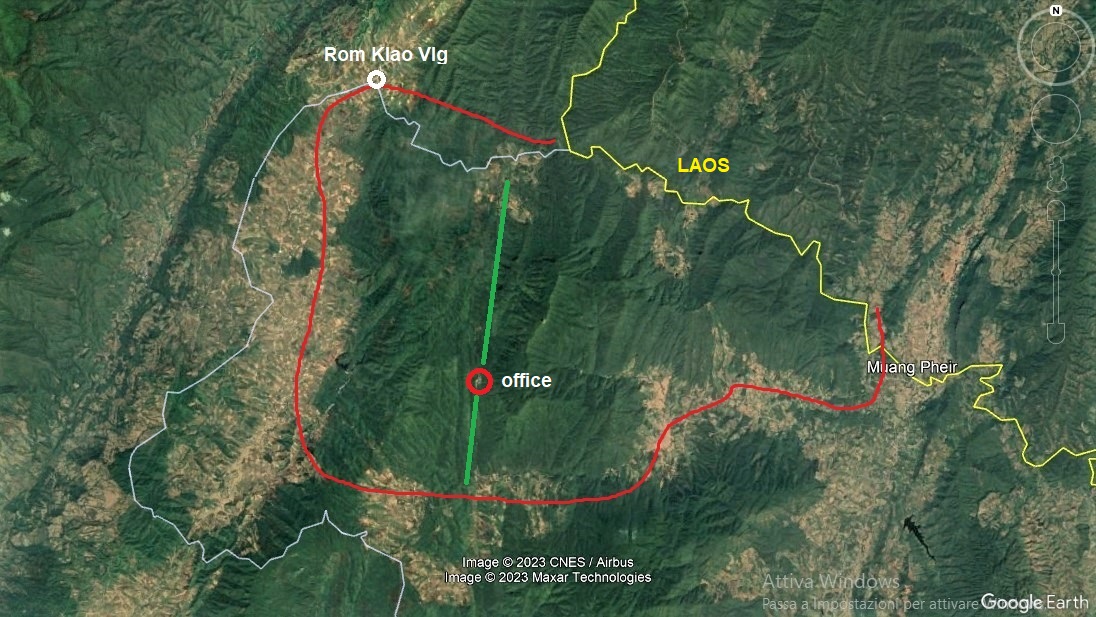
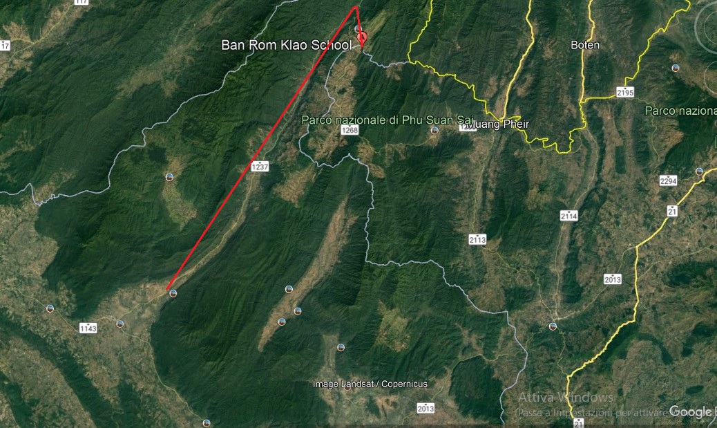
2023: The old Na Haeo Forest Park is today Mt Suan Sai National Park (17 31.268, 100 56.968), between Chat Trakan Falls and Laos: photo (yellow line: Laos border; white line: province border; red line: park border; green line: road across the park). The songthaew followed a straight road that goes from Chat Trakan Falls to Rom Klao Vlg, the red line here: photo. To get to the park office, the driver should have gone from Rom Klao Vlg back to the south-west of the park (it's the same road he took from Chat Trakan Falls), then taken another road to the south of the park, and then go north. That's quite a distance, and all out of his normal route. There should be some public transport going that way, but he just left me at the local border police outpost to look for some help, at which point I probably surrendered and just tried to go back home. My hotel owner called the park weeks later, and they said there are no pitcher plants. Anyway, I can see now that Na Haeo doesn't host any forest good for N. smilesii. The email thing: I don't know why they do that, I was given tens of email addresses during my first years of travel, but whenever I sent a message, nobody ever replied. With a girl in particular (28 y.o.), as she never got back to me, the following year I had a chance to discuss the issue and check her email account together with her, and we both found out that she hadn't read any message from anybody for the past three years. "Why?", "I don't know" (laughs). So, even if they can't speak or write in English, even if they don't check their emails, even if they don't have a computer, giving their email address makes them feel in touch with the rest of the world, who knows.
Mt Ruea and Mt Luang (January 31). When people pronounce R and L in the same way, placing a park named Mt Ruea next to a park named Mt Luang, ehm, not a good idea? Jokes apart, despite the obvious difficulties when hearing or pronouncing the two names, I do reach both parks and both headquarters, where I'm told that, unfortunately, they don't have pitcher plants. Lift after lift, bus after bus, I'm back home by midnight.
2023: No Nepenthes have ever been reported from the two parks (Mt Ruea: 17 30.358, 101 20.686; Mt Luang: 17 14.972, 101 32.215), but they both seem to have the right habitats at the right altitude, plenty of open areas at 1200-1300 m, with plenty of trails, and the soil looks particularly good on Mt Ruea, so I would keep these in the maybe bucket.
Kaeng Chet Kwae (February 8). On this cool and sunny morning, after a 6 km walk from the bottom to the top of the mountain, where the first office is, I ask a guard if he knows anything about the presence of pitcher plants in the surroundings. After half an hour of unilateral conversation with the most unaware pair of eyes that I've ever seen, the kind gentleman finally understands what I am asking for, and he goes to interrogate a few friends. Then he comes back and confirms that there's no trace of pitcher plants in the area. Instead, to his friends' opinion, I should go to Mt Ruea.
2023: The park changed its name to Khwae Noi but it still includes a forest park (one of four) named Kaeng Chet Kwae, which should be in the southeastern section: photo. All the present offices are in the lowlands of the northwestern section (17 10.545, 100 23.837), so it's hard to tell what's the spot where I asked in 2004. Both sections are covered with hills and thick forest, no N. smilesii for sure. In particular, and that only becomes clear with a closer and inclined satellite view, the southeastern section is no less than the narrow, lateral slope of a plateau: its flat top and bottom were developed, while the side was preserved.
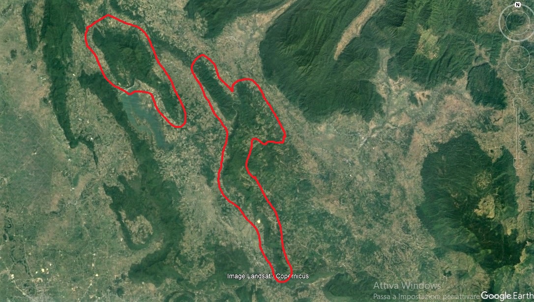
Sak Yai and Khlong Tron (February 10). I take a bus to Uttaradit and I try to see how to reach Sak Yai from there. After walking for a couple of hours in different directions, I am told by an old man to "go that way". I quickly find myself on what should be the right way, which is an unpaved road lost among millet fields. It looks like a Stephen King story, but not even the great writer could have made up the events that followed. I wait to see if I can stop a car, but I get nothing for about thirty minutes. Then, when I finally hear an engine noise, I raise my hand to stop it, whoever or whatever that is. It gets closer, it slows down, and it stops. It's an ambulance. A very old man is driving, with a young nurse next to him. I tell them where I'm going, they are happy to help. I open the back doors, only to see another two young nurses smiling and waving at me. A true Japanese cartoon. The old man drives like crazy because there's no one else on the road and an ambulance can go as fast as it wants. In ten minutes, we reach Sak Yai. Once there, some local people tell us that the headquarters of the Sak Yai National Park are in the Khlong Tron National Park. I tell the girls that I need the headquarters rather than the park itself, so again they are happy to bring me to Khlong Tron.
Even if getting to Khlong Tron only takes another twenty minutes, at the entrance we are told that the office is 2 km far, up on the mountain. And yes, the old man, probably now even more confident about what he's doing and taking my mission as his mission, starts driving the shaky ambulance very slowly over the narrow, unpaved and pebbly road, while I and the girls in the back bounce and look with terror at the deep valley on the right. After 2 km on the scary road, we reach the headquarters. The girls start asking a local about the pitcher plants, while I run up to the offices, where a few guys and girls are relaxing on their chairs. They see me rushing, they welcome me with a placid "hallooo", and they slowly and calmly move to try and help me. I have the impression that they are even too slow and calm, so I approach one guy, I bring him to the window, I say: "Fast! Fast!", and I point at the ambulance in the car park. He shouts something in Thai to the others, and now they are indeed moving much faster. We look in all their archives, we check all the photos they have taken during their expeditions in the park. Nothing. They also say that, as far as they know, there are no pitcher plants there. I go back to the ambulance and the girls kindly tell me that now they really have to go, because that's one of the only two ambulances they have in the Uttaradit area, and they are bringing food and drink to the hospital. So, talking about Thai kindness, quite a record set there. They bring me to a police station, where I have my lyophilized noodles while waiting for the bus. Meanwhile, a police officer and another couple of guys go to the tamarind tree in front of the station, they shake it and, well, I go home with enough tamarind for a month.
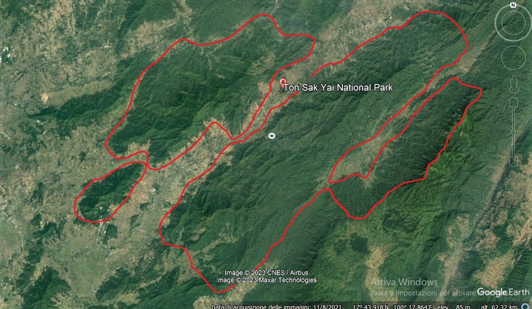
2023: In Nepenthes della Thailandia, the ambulance story was placed under Mt Pha Lek for narrative purposes, here it's back in the right place. The name of the park was changed from Khlong Tron to Ton Sak Yai in 2012, probably after lumping together the two sections. The satellite image suggests that we first went to the northwestern section named Sak Yai, and from there we went to the southeastern section named Khlong Tron, where I can see a road going up to some offices on the mountain (the white dot in the previous image), with a valley on the right (17 35.845, 100 32.987): photo. There are no habitats good for N. smilesii. Looking at the road back to the first village, at the main road that crosses that village, at trees, houses, offices and bus stops, I assume I was left at the post office, where seeing a policeman or anybody in uniform made me think about a police station; the place looks familiar and the tamarind tree is of the size and in the corner that I remember: 17 36.649, 100 31.659.
Ramkhamhaeng (February 11). After a couple of buses and a lift, I arrive at the park and I am welcomed by the friendly people of the headquarters. In few minutes, they are able to tell me that for sure there are no Nepenthes there. I wait for about an hour at the entrance shed, together with them, having my noodles and waiting for a car to go back to the bus station. Meanwhile, they ask me about Vieri and Baggio, they are curious to know whether Italian girls are beautiful or not, and they try to play chess with me (I can't play chess). I show my map and I explain how my research is proceeding. Each one of the six or seven guys starts pointing at a different park on the map, saying: "There, there you can find pitcher plants!". All places where I have already been and found nothing.
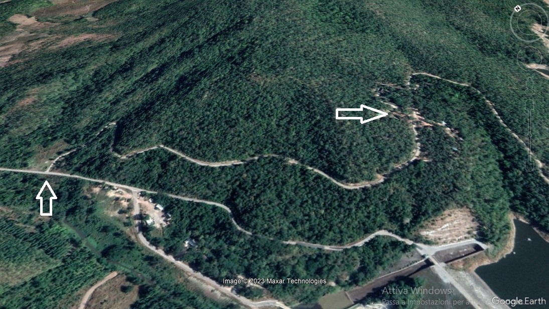
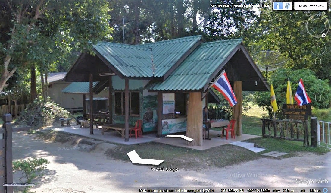
2023: Even if Ramkhamhaeng hosts interesting, large clearings at 1000-1200 m, these are tourist spots that have been visited over and over again, and no Nepenthes have ever been reported. It's also too far from even the westernmost N. smilesii location. The headquarters are somewhere around 16 52.649, 99 41.582, but it sounds like in my notes I'm rather referring to the entrance offices at 16 52.602, 99 42.556: photo.
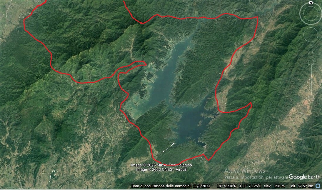
Lam Nam Nan (February 14). Fortunately, on the way back from Khlong Tron, I had seen the entrance of this other national park, an entrance that, looking at my map, should have been in a completely different place. The park extends all around an enormous lake. I have a nice 4 km walk up to the headquarters. What a shame that the lake is not visible from there. I ask an officer about the pitcher plants and he goes to ask someone more in the know. Then this girl comes, and she tells me that no Nepenthes are growing there.
2023: Lam Nam Nan has a very complicated structure (photo) but it's all thick forest. No plateaus, no sandy and grassy clearings, no Nepenthes. It sounds like I walked from the junction at 17 45.107, 100 28.123 until the offices at 17 46.056, 100 29.365 (it's the line with two dots). Amazing how I forgot all that.

Thai locations where I didn't find Nepenthes
Trip 2004
Trip 2006
Trip 2007
Trip 2008
| © Marcello Catalano 2026 | rafflesiana@yahoo.com | Privacy policy |